

Iorras Beag [Errisbeg]
Good walks are even better shared.
L6940 : Triangulation pillar
Jonathan Wilkins Photo source
Overview
Iorras Beag [Errisbeg]
Nestled in the heart of Connemara, Iorras Beag, or "little Iorras," offers a delightful blend of challenging hikes and breathtaking views. The granite peaks rise to an elevation of 202 meters, providing a stern reminder that while size doesn't always matter, its stature boasts a prominence of 105 meters that can make the heart race!
Geology
The mountain's granite base features various interesting formations created over millennia. While it presents a solid foundation, this rocky surface can be tricky underfoot, particularly on wet days. It’s a good idea to bring your best hiking boots and perhaps a sense of balance!
Access and Facilities
Accessing Iorras Beag is as straightforward as a good old-fashioned hike. The nearest parking is located at Ballinaboy, just a stone’s throw from the trailhead. Public transport lovers can catch a bus to Roundstone, followed by a short taxi ride. Remember, the locals are always ready with a warm smile and maybe some homemade soda bread if you’re lucky!
In Roundstone, you’ll find various cafés where you can savour a well-deserved coffee after a climb.
Routes
Hikers can choose from various routes:
- Errisbeg Loop (6.0 km): A gentle loop offering fantastic panoramas of the surrounding landscapes.
- Direct Ascent from Ballinaboy (3.0 km): For those looking for a challenge, this ascent takes you straight up to the summit! Just remember, with great heights comes great responsibility — like checking the weather.
Summit Features
At the summit, you'll encounter a charming cairn, which serves as a landmark for weary hikers, and a stone circle perched fabulously for photo ops (try not to think about the elves hiding when you snap that selfie!).
Terrain and Hazards
The terrain varies from rocky cliffs to grassy inclines, with a few marshy patches to keep you on your toes! Beware of rapidly changing weather conditions, which are as unpredictable as your mate deciding to join a 5-a-side team on the spur of the moment.
Views
Once at the top, feast your eyes upon stunning vistas: the enchanting Atlantic rushes forth, the Twelve Bens pose majestically, and the colourful little village of Roundstone sits beneath you. If you’ve come during spring or summer, the views are even more picturesque. In autumn, prepare for breathtaking colours worthy of an art gallery.
Conclusion
Whether you’re embarking on a casual walk or seeking a heart-pounding climb, Iorras Beag is a wonderful escape into Ireland’s natural majesty. Just make sure to pack your sense of adventure, and don't forget to take a moment to enjoy the view — it’s simply breathtaking!
Happy hiking!
Explore routes near Iorras Beag [Errisbeg]
Walks starting near this hill. Open a route to check its map, distance and full itinerary.
Route planning notes
These notes describe possible approaches. Check a route's map and access information when planning your walk.
Errisbeg Loop
A scenic route that loops around the base of Iorras Beag, offering gradual ascents and stunning views.
Direct Ascent from Ballinaboy
A more challenging trek that leads directly to the summit, suitable for fit walkers looking for a good hike.
Make a day of it, together
Find someone to share the walk with, or organise a day out along a route you like.
Photo Gallery
View all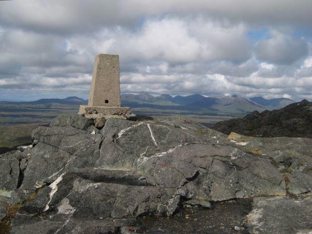 Photo could not load
L6940 : Triangulation pillar
Jonathan Wilkins
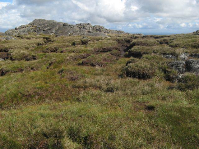 Photo could not load
L6940 : Erosion of blanket bog
Jonathan Wilkins
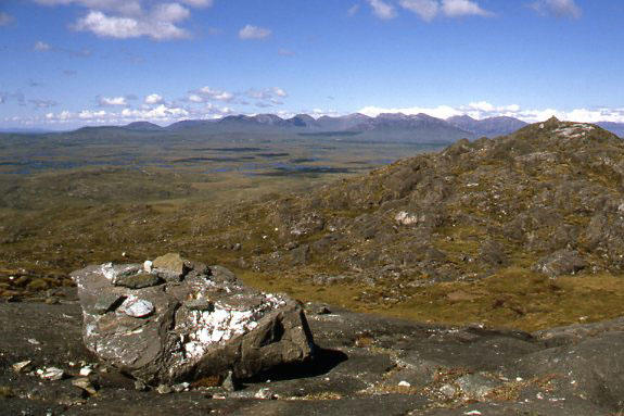 Photo could not load
L6940 : Errisbeg & the Twelve Pins
Ian Taylor
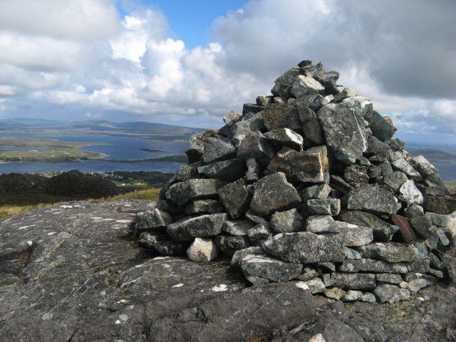 Photo could not load
L6940 : Another cairn
Jonathan Wilkins
Hill facts and local notes
Classifications
Elevation
300m
984 ft
Prominence
279m
Coordinates
53.3965, -9.9567
L698402
OS Map
44
At the Summit
The summit features a prominent cairn and a stunning stone circle, which locals have claimed to have magical properties… or maybe that’s just the view playing tricks on you!
Terrain & Geology
Iorras Beag is primarily composed of granite, which provides a sturdy base but can be quite craggy in parts. The erosion of softer materials has left interesting formations that both challenge and entice skiers and ramblers alike.
Views & Scenery
From the summit, hikers can see the sparkling waters of the Atlantic Ocean, the Twelve Bens mountain range, and the picturesque village of Roundstone.
History & Heritage
Name Origin
Iorras Beag translates to 'little Iorras', with 'Iorras' often associated with marshy land.
Historical Significance
The area is steeped in Irish folklore, and the mountain has been a silent witness to the traditions and stories of local clans.
Getting There & Facilities
Parking
Parking is available at Ballinaboy, approximately 1km from the foot of Iorras Beag.
Public Transport
Bus services run to Roundstone from Galway, followed by a short taxi or bike ride to the trailhead.
Nearby Facilities
The charming village of Roundstone has several cafés and shops for refreshments and supplies, and public toilets are available.
Safety Information
Known Hazards
- Variable weather conditions can change rapidly, leading to challenging visibility; be prepared for all seasons! Take care on rocky paths, particularly in wet conditions.
General Safety Tips
- Check weather conditions before setting out
- Carry appropriate clothing and equipment
- Let someone know your planned route
- Take a map, compass, and GPS device
- Carry emergency supplies: food, water, first aid kit, torch
Hills
Some common questions about the hills answered
Are there group walks up Iorras Beag [Errisbeg]?
Many walkers use Walkmates to join or organise walks with others. You can check for group walks around Iorras Beag [Errisbeg] through the maps
Are there other walkers around Iorras Beag [Errisbeg]?
Activity varies by location and time, but Walkmates lets you see whether others have shared walks or shown interest in this area. Find other people through the walking friends search walking friends for Iorras Beag [Errisbeg] search or of course create your own walk for Iorras Beag [Errisbeg]
Can I organise a walk to Iorras Beag [Errisbeg]?
Yes. If there aren’t any walks listed already, you can create a walk and make it available for others to join.
If you're signed up to Walkmates, you can create a walk to Iorras Beag [Errisbeg].
How do I find a walk up this hill?
There are often multiple ways to walk this hill, depending on experience and route preference. Walkmates helps you explore walks and routes that others have shared.
Can I suggest a new route up Iorras Beag [Errisbeg]?
Yes. You can suggest or create routes to share with others. Walkmates focuses on the social side of walking, so routes are used to help people organise walks and explore areas together, rather than as detailed navigation tools or route libraries.
Other uses really appreciate knowledgeable walkers sharing their routes. Share your favourite route to Iorras Beag [Errisbeg] here
The is an error or something incorrect about this hill. How do I let you know?
We always strive to keep the information on Walkmates as accurate as possible. If you find an error, please let us know through the contact form and we'll aim to correct it as quickly as possible
Community Discussion
Comments
Location
![Iorras Beag [Errisbeg] location map](https://cdn.walkmates.com/hill-maps/hill-sources/20478/53.39651_-9.95674.png)
Grid reference: L698402
View on OpenStreetMapOpens a map in a new tab, centred on the hill.
No comments yet. Be the first.